

Tourist trails
Green trail
The trail starts in Gorlice and ends in Ozena village.
From Wapienne village to Ozenna village it runs through the area of the Magura National Park and its buffer zone.
The trail length in this part: 41.5 km
Category: for pedestrians
Trail’s profile
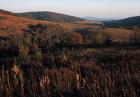
The trails leads from Gorlice towards SE. It comes into the area of the Park in Wapienne village. It runs quite steep from the sanatorium buildings up the long ridge with the Maly Ferdel Mt. culmination (578m a.s.l.). Then the trail goes along an old path running along the forested ridge, it goes up the Ferdel Mt. peak (648m a.s.l.) and bypasses it from S. Halfway between those culminations a short blue trail from Rozdziele village joins it from N. Then it reaches the main ridge of Magura Watkowska Mt. From that place it leads along the Park’s border, which runs along the ridge, until it joins the red trail. Then it goes by an old path through forested area with almost no clearings. The path is in rather good condition but there are boggy areas and mud in some places. In the area of Barwinek Mt. (670m a.s.l.) a black trail from Folusz village to Ferdel Mt. joins the green one from E and ends in that spot. Then the green trail passes another hills (703m a.s.l., 723m a.s.l.) and it goes to the nature reserve Kornuty. There on a small glade a path branches off right leading to the edge of a cliff. The trail goes on and reaches a characteristic flat area (820m a.s.l.) with a crossing of several tourist trails. There, across the ridge, from N to S a yellow trail Folusz – Bartne – Konieczna runs. The green trail goes on SE along quite characteristic ridge with some clearings of glades and some rock debris. Passing by a small water flow ravine it crosses the main culmination of Watkowa Mt. (846m a.s.l.) and then it runs down to some lower part before the other culmination of Magura Mt. (829m a.s.l.). A red trail comes to that lower part from S, from Bartne village. The green trail runs further E along the red one. After a while it turns left. Running down through forest it comes to a road, turns left and then right and comes down quite steep. The trail runs to the next forest road and follows it along the Klopotnica stream valley. On a crossing (where a black, a yellow and a green trails cross) it turns right, crosses a stream and together with a yellow trail it goes to Folusz village. The trail passes by an old lumber and next – a place for a rest. The trail reaches Folusz village and goes SE. Slightly above the last buildings it enters the Park’s area. There is a barrier on the road there and next to it a parking with a place for rest. Behind the barrier the trail branches off right leading to the Magura Waterfall. Then the green trail leads by the road up the forested Potasowka stream valley. Then, after about 3km, on a sharp bend it turns left and using some old forest roads it goes up the ridge going from Smyczka Mt. towards Zamkowa Mt. It reaches a wide col between those two peaks where the area of he MNP is no more, only some private forest. Then the trail runs down the road into the Szczawa stream valley where it joins the yellow trail Mrukowa – Krempna. There it turns NE and goes to the centre of Mrukowa village. There is a tourist trails crossing next to a bus stop. The green trail leads further through Bucznik Mt. (518m a.s.l.), Nowy Zmigrod village and Grzywacka Mt. (567m a.s.l.) to Katy village. Behind a bridge on Wisloka river in Katy village it turns left. It leads along a road that goes steep u the ridge of a hill. Then it leads along a long open ridge called Na Gorach Mt (468m a.s.l.) to Kamien Mt. At the end of the ridge it goes into forest which is located already in the area of the Park. The path goes up and then turns right and after that left a begins to climb up the hill quite steep to the Kamien Mt. ridge crossing it slightly S from the main culmination. After passing the ridge it runs down the S side of the mountain to the forest path where it turns left and it runs towards a wide ridge. Then along an old path it goes S. On a bend it leaves the ridge running down into the Wisloka river valley. After leaving the forest area (MNP’s border) the trail goes on the open hill (452m a.s.l.) with wide views on Krempna village, Wisloka river valley and its surrounding. The path running through some meadows and shrubs comes down into the centre of the Krempna village. From Krempna the trail goes S to Ozenna village. After 5km right before the inhabited village called Zydowskie it turns right and by a small road, along the edge of forest and meadow it goes up on Wysokie Mt. (658m a.s.l.). A wide panorama might be admired on the peak. The path runs down S through some meadows, then it goes deep into the wild young woodland, which overgrows old farmlands. After some time the trail goes into a comfortable path which runs through a beech forest to a wood yard located on a road bend from Krempna to Grab village. It turns right and runs to Ozenna village where it finishes its run. Coming close to a forest border the trail goes at some open areas where is a beautiful view onto the Ryjak stream valley with Ozenna and Grab villages might be admired.
Walking times:
Wapienne village – Ferdel Mt. 1h
Ferdel Mt. – Kornuty Mt. 1h15’
Kornuty Mt. – Magura Watkowska Mt. 1h
Magura Watkowska Mt. – Folusz village 1h30’
Folusz village – Waterfall 40’
Folusz village – Mrukowa village 2h 30’
Mrukowa village – Nowy Zmigrod village 2h
Nowy Zmigrod village – Grzywacka Mt. 1h30’
Grzywacka Mt. – Katy village 30’
Katy village – Krempna village 1h 15’
Krempna village – Wysokie Mt. 2h
Wysokie Mt. – Ozenna village 1h